Stop guessing.
One better starting point can save days of scouting.
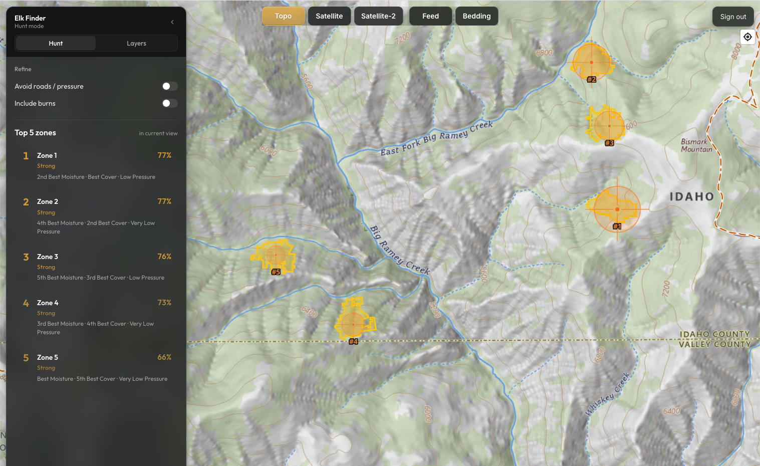
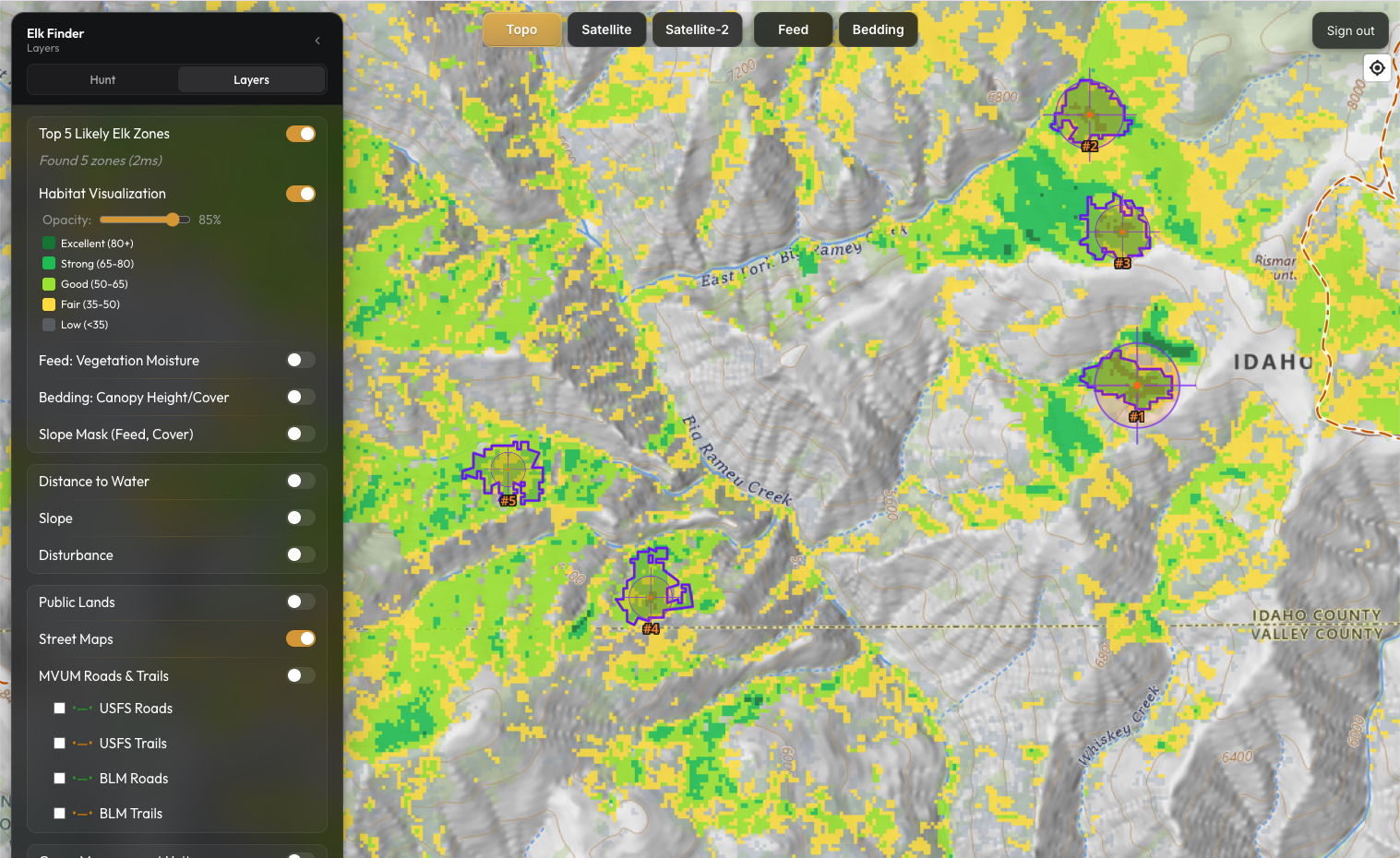
Elk Finder analyzes the habitat inside your unit and ranks the top five zones anywhere you view. It also shows you the feed, bedding cover, terrain, water, and road pressure behind every result.
Full access to all 11 western states
Annual subscription · Immediate access · Cancel renewal anytime

Trusted by Western Hunters
See What Hunters Are Saying
Read the Elk Finder launch discussion, questions, and feedback from Rokslide members.
Read the Rokslide threadTested Against Known Elk Country
Rokcast host Sam Weaver compared Elk Finder's results with areas where he had previously found elk. (Elk Finder discussion starts at 55:00)
Listen to the episodeHow it works.
You do not need years of elk experience to understand the results. Elk Finder shows the feed, cover, terrain, and access conditions that made each zone stand out, all built on data hunters can verify.
Vegetation moisture can help identify areas with stronger potential feed.
Satellite moisture data shows where vegetation is still holding water deep into the season. Elk Finder points you to feed that's still working, not just feed that was green in July.

Elk need cover.
LANDFIRE vegetation data shows where timber and brush are tall enough and dense enough to bed in. You already know what bedding country feels like underfoot. Elk Finder helps you find more of it without burning a day to check.

Terrain does half the work.
Slope analysis filters out the flat ground and the dead vertical that elk avoid. You're left with country shaped the way elk like it.

Start where everyone else does not.
Prepared hunters know the trailhead bowls get hammered. Elk Finder favors zones farther from easy motorized access, so you're not starting where every other tag holder starts.

LANDFIRE is an interagency program led through USDA Forest Service Fire and Aviation Management and the Department of the Interior Office of Wildland Fire.
Live demo
Try the real map in a limited Idaho demo area.
Zoom in, switch layers, inspect habitat, and run Hunt Mode on the same map experience used in the paid product.
Buy NowThis season's moisture data is already in the map.
- Available now: September 2026 moisture data, built from satellite passes August 15–31, 2026
September 2026
Current-season satellite moisture across all 11 western states. It drives Feed, Likely Elk Zones, and Habitat Visualization.
September 2025
Last fall's moisture stays one click away in the Season selector, so you can see how feed in your unit changed year over year.
October 2026 moisture
Moisture from satellite passes in late September, for hunters planning October rifle seasons.

Why I built Elk Finder.
I’ve hunted public land elk in Idaho, Oregon and New Mexico, and I’ve made plenty of the same mistakes most hunters make: burning too much time in dead country trying to figure out where elk should be.
Time is a huge factor for all of us and I wanted a quicker way to find promising elk habitat in the mountains where I live, in McCall, Idaho.
As a software engineer with 20 years of experience, I took a first principles approach to identifying elk habitat based on elk needs and behavior.
Elk Finder takes satellite and terrain data and turns it into a practical way to find country where feed, bedding cover, slope, and low pressure come together.
I built Elk Finder for myself. When I compare Elk Finder against places where I have previously encountered or harvested elk, it highlights many of the same habitat patterns, including the areas where I harvested my first archery elk in Idaho and my rifle elk in New Mexico.
It won’t kill an elk for you. It won’t replace boot leather, wind sense, patience, or good decisions in the field.
But it can help you stop wasting the best days of your season in the wrong country.
Jon Olson
- McCall, Idaho · LinkedIn
- [email protected]
- 20 years software engineering experience
- 10 years hunting public land in Idaho, Oregon, and New Mexico
Full Access to Elk Finder
One better starting point can save days of scouting.
- Top five ranked habitat zones anywhere you view
- Pre-calculated elk hotspots for more than 1,000 game management units across 11 western states
- Arizona
- California
- Colorado
- Idaho
- Montana
- Nevada
- New Mexico
- Oregon
- Utah
- Washington
- Wyoming
- Feed, bedding cover, terrain, water, and road pressure analysis
- Topographic, satellite, public land, road, trail, and GMU layers
- Current-season moisture updates included
Immediate access · Secure Stripe checkout · Cancel renewal anytime
Renews annually until canceled. Terms.
Why are subscriptions not refundable?
Full access to the map, habitat analysis, and ranked zones is delivered immediately after purchase. Because the complete scouting database becomes available as soon as you subscribe, annual subscriptions are not refundable. Explore the live Idaho demo and review the included features before purchasing.
Already use onX or GOHUNT?
A Different Kind of Elk Scouting App
onX helps you navigate, understand access, and use maps in the field. GOHUNT helps you research tags, hunts, and units. Elk Finder analyzes the habitat inside the unit you already chose, so you know where to start looking.
| Tool | Primary role in your workflow | What it helps you answer |
|---|---|---|
| onX Hunt | Boundaries, navigation, offline maps, routes, and waypoints | Where can I navigate? |
| GOHUNT | Draw odds, hunt research, unit information, and planning tools | Which unit should I pursue? |
| Elk Finder | Ranked elk habitat based on feed, bedding cover, terrain, water, and access | Where should I start scouting inside my unit? |
Elk Finder complements your existing hunting apps. It does not try to replace them.
What Elk Finder Does and Does Not Do
Elk Finder does:
- Rank habitat zones worth investigating first
- Explain the habitat signals behind every result
- Help reduce a large unit into a manageable scouting shortlist
- Help hunters compare feed, cover, terrain, water, and access
Elk Finder does not:
- Guarantee that elk are currently inside a ranked zone
- Predict daily elk movement
- Replace boots on the ground scouting
- Replace navigation, access, or offline map applications
Common questions
What Elk Finder Does
Is this a guarantee I will find elk?
No. Elk Finder is a scouting tool that helps you start in better elk country. It narrows a unit into places worth checking first.
What are Likely Elk Zones?
Likely Elk Zones are places where multiple elk habitat signals come together, including feed, bedding cover, usable slope, and optionally lower road pressure and proximity to disturbance (burns & clearcuts).
How is Elk Finder different from normal hunting maps?
Most hunting maps give you layers and leave the sorting to you. Elk Finder helps sort the habitat first by showing where feed, bedding cover, and usable terrain come together.
Do I still need onX, goHunt, or another GPS app?
Maybe. Elk Finder is focused on habitat scouting and planning. If you use another app for GPS tracking in the field, private landowner details, draw odds, or legal boundary verification, it can still be part of your workflow.
Does Elk Finder replace boots on the ground scouting?
No. It helps reduce wasted scouting by pointing you toward better starting areas. You still need to confirm with fresh sign, current conditions, wind, and access.
Data And Habitat Logic
What data does Elk Finder use?
Elk Finder uses satellite moisture data, LANDFIRE vegetation cover and height, terrain analysis, road and trail distance. It includes layers for public and private land boundaries, GMUs, topographic maps, and satellite basemaps.
What is NDMI and why does it matter?
NDMI is a satellite-derived moisture index that estimates vegetation water content. For hunters, it helps show where feed may still be holding moisture instead of relying only on how green an area looks from above.
What moisture data is included today?
Elk Finder includes September 2026 moisture data, built from satellite passes August 15–31, 2026. September 2025 moisture is still available in the map's Season selector, so you can compare this fall against last fall in your unit.
How are feed and bedding areas identified?
Feed is estimated from moisture-related forage signals. Bedding cover is estimated from vegetation height and canopy coverage, so the app can better separate real security cover from low brush or open ground.
Is road distance the same as hunting pressure?
No. Road distance is a practical pressure proxy. It cannot predict every hunter or every access route, but it helps show where motorized access is easier and where elk may find more security once pressure builds.
Is Elk Finder an AI black box?
No. Elk Finder is driven by data and explainable. You can inspect the individual layers behind a zone so you can see the feed, cover, terrain, and access context that made it stand out.
Coverage And Map Layers
What states does Elk Finder cover?
Elk Finder covers 11 western elk states: Arizona, California, Colorado, Idaho, Montana, Nevada, New Mexico, Oregon, Utah, Washington, and Wyoming.
Does Elk Finder include public lands and GMUs?
Yes. Elk Finder includes public land layers, public land type distinctions, Game Management Units, roads, Motor Vehicle Use Maps and trails, topographic basemaps, and satellite basemaps.
Does Elk Finder include private land?
Elk Finder includes public and private land boundary context, but it does not include private landowner names or ownership contact information.
Is Elk Finder showing legal land boundaries?
Elk Finder provides land boundary context for scouting and planning, but you should verify legally important boundaries and access rules with official sources before relying on them in the field.
What are Motor Vehicle Use Maps?
Motor Vehicle Use Maps show official Forest Service road and trail designations. Elk Finder uses them to help you understand legal motorized access, trail systems, and how easy it may be for hunters to reach an area.
Seasons And Species
What season is Elk Finder built for?
Elk Finder is built for September archery and October rifle planning. The same habitat basics still matter, but the importance of moisture, bedding cover, terrain, and pressure changes as the season progresses.
Does it work for every elk unit the same way?
Elk Finder uses a consistent habitat framework across the West, but elk country varies by state, elevation, vegetation, weather, and local pressure. Treat the results as a strong starting point and adjust with local knowledge.
Can I use Elk Finder for mule deer or other species?
Elk Finder is tuned for elk habitat. Some layers may be useful for thinking about other species, but the highlighted zones and defaults are built around elk behavior and elk habitat needs.
Device Access
Does Elk Finder work on my phone?
Yes. Elk Finder works well in mobile browsers, so you can use it on a phone when you have service. A dedicated mobile app is not available yet.
Does Elk Finder work offline?
Not yet. Offline maps are planned with the future mobile app. Today, Elk Finder works best for planning at home and for mobile browser use where you have cell service.
Account And Pricing
What does the subscription cover?
Your subscription gives you access to Elk Finder's habitat analysis, map layers, and supported western elk states for one year from the day you purchase.
Does the subscription renew automatically?
Yes. Elk Finder renews annually. You will receive an email reminder two weeks before your renewal date.
What happens if the price changes before my renewal?
The renewal price is not fixed forever. If the price changes before your renewal, Elk Finder will notify you ahead of time so there are no surprise renewal charges.
Can I get a refund?
No. Because full access to the map, habitat analysis, and ranked zones is delivered immediately after purchase, annual subscriptions are not refundable. Explore the live Idaho demo and review the included features before purchasing.
Waypoints And Privacy
Can I save and export waypoints?
Yes. Paid members can save private waypoints on the map and export them as a GPX file for use in compatible mapping apps. Marker colors and icons may look different after import.
Will my spots be shared or sold?
No. Your saved scouting spots will not be shared or sold. Waypoints are designed to stay private to your account.